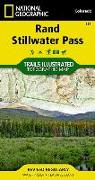
Green Mountain Reservoir, Ute Pass Map
National Geographic Maps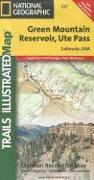
Coverage includes the Arapaho National Forest, Eagles Nest and Ptarmigan Peak wilderness areas, Heeney, Green Mountain Reservoir, Cataract Lakes and Black Lake, as well as Ute Pass. Includes UTM grids for use with your GPS unit.
![San Rafael Swell Map [Blm - Price Field Office]](https://support.digitalhusky.com/media/annotations/sorted/108/10860808/CHSBZCOP0310860808.jpg)
![Paiute Atv Trail Map [Fish Lake National Forest, Blm]](https://support.digitalhusky.com/media/annotations/sorted/108/10860804/CHSBZCOP0310860804.jpg)