Joshua Tree National Park Map
National Geographic Maps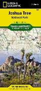
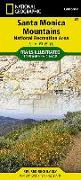
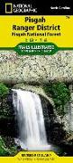
National Geographic's Trails Illustrated Maps are the most detailed and up-to-date topographic recreation maps available for US National Parks, National Forests and other popular outdoor recreation areas. A necessity for exploring the outdoors, each map is printed on waterproof, tear-resistant material. They also contain key safety and contact information, GPS and compass coordinates, Leave No Trace ethical guidelines and hundreds of points-of...
![Staunton, Shenandoah Mountain Map [George Washington and Jefferson National Forests]](https://support.digitalhusky.com/media/annotations/sorted/485/4852758/CHSBZCOP034852758.jpg)
![Merced and Tuolumne Rivers Map [Stanislaus National Forest]](https://support.digitalhusky.com/media/annotations/sorted/485/4852734/CHSBZCOP034852734.jpg)
![Longs Peak: Rocky Mountain National Park Map [Bear Lake, Wild Basin]](https://support.digitalhusky.com/media/annotations/sorted/479/4793084/CHSBZCOP034793084.jpg)
![Massanutten and Great North Mountains Map [George Washington National Forest]](https://support.digitalhusky.com/media/annotations/sorted/479/4793078/CHSBZCOP034793078.jpg)


![Sangre de Cristo Mountains Map [Great Sand Dunes National Park and Preserve]](https://support.digitalhusky.com/media/annotations/sorted/479/4793069/CHSBZCOP034793069.jpg)
![Baja North: Baja California Map [Mexico]](https://support.digitalhusky.com/media/annotations/sorted/771/7710863/CHSBZCOP037710863.jpg)