Suche einschränken:
Zur Kasse

1286 Ergebnisse - Zeige 21 von 40.

Boulder, Golden Map

National Geographic Maps
Boulder, Golden Map
National Geographic's Trails Illustrated Maps are the most detailed and up-to-date topographic recreation maps available for US National Parks, National Forests and other popular outdoor recreation areas. A necessity for exploring the outdoors, each map is printed on waterproof, tear-resistant material. They also contain key safety and contact information, GPS and compass coordinates, Leave No Trace ethical guidelines and hundreds of points-of...

Fontana and Hiwassee Lakes Map [Nantahala National Forest]

National Geographic Maps
Fontana and Hiwassee Lakes Map [Nantahala National Forest]
National Geographic's Trails Illustrated Maps are the most detailed and up-to-date topographic recreation maps available for US National Parks, National Forests and other popular outdoor recreation areas. A necessity for exploring the outdoors, each map is printed on waterproof, tear-resistant material. They also contain key safety and contact information, GPS and compass coordinates, Leave No Trace ethical guidelines and hundreds of points-of...

Delmarva Peninsula Map

National Geographic Maps
Delmarva Peninsula Map
National Geographic's Trails Illustrated Maps are the most detailed and up-to-date topographic recreation maps available for US National Parks, National Forests and other popular outdoor recreation areas. A necessity for exploring the outdoors, each map is printed on waterproof, tear-resistant material. They also contain key safety and contact information, GPS and compass coordinates, Leave No Trace ethical guidelines and hundreds of points-of...

Acadia National Park Map

National Geographic Maps
Acadia National Park Map
Updated to reflect road closings, new trails, and campground relocation, and includes detailed trail information, points of interest, trailheads, picnic areas, facitlities, and more. Features Mount Desert Island, Sestern Mountain, Norwood Ridge, Freeman Ridge, Isle au Haut, Marshall Island, Swans Island, Western Bay, Mount Desert Narrows, Eastern May, Frenchman Bay, Eastern Way, Eastern Passage, Long Pond, Seal Cove Pond, Echo Lake, Somes Soun...

Grand Staircase, Paunsaugunt Plateau Map [Grand Staircase...

National Geographic Maps
Grand Staircase, Paunsaugunt Plateau Map [Grand Staircase-Escalante National Monument]
- Waterproof - Tear-Resistant - Topographic MapOutdoor enthusiasts seeking to enjoy the abundance of public lands and endless recreational opportunities in southern Utah will marvel at National Geographic's Trails Illustrated map of Grand Staircase and Paunsaugunt Plateau. Created in cooperation with the Bureau of Land Management, U.S. Forest Service, National Park Service and others, this expertly researched map provides unmatched detail betw...

Paria Canyon, Kanab Map [Vermillion Cliffs National Monum...

National Geographic Maps
Paria Canyon, Kanab Map [Vermillion Cliffs National Monument, Grand Staircase-Escalante National Monument]
- Waterproof - Tear-Resistant - Topographic MapStraddling the border of Arizona and Utah, the Paria Canyon-Vermilion Cliffs Wilderness is a colorful landscape of sandstone cliffs, slot canyons, and winding waterways. National Geographic's Trails Illustrated map of Paria Canyon and Kanab is designed to meet the needs of outdoor enthusiasts by combining valuable information with unmatched detail of this remarkable region. Created in partnership ...

Jamaica Map

National Geographic Maps
Jamaica Map
- Waterproof - Tear-Resistant - Travel MapNational Geographic's Jamaica Adventure Map is designed to meet the needs of adventure travelers with its detailed and accurate information. This map includes the locations of cities and towns with a user-friendly index, a clearly marked road network complete with distances and designations for roads/highways, plus secondary routes for those seeking to explore off the beaten path. Adventure Maps differ...

National Geographic Battles of the Civil War Wall Map (35...

National Geographic Maps
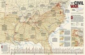
National Geographic Battles of the Civil War Wall Map (35.75 X 23.25 In)
This comprehensive map shows major land campaigns, Union and Confederate troop movements, major Union naval campaigns, roads, railroads, battle outcomes and their impacts on the war, dates of capture by Union forces and more. Two inset maps - Battle for the Capitals and Turning Points of the War - as well as a timeline of battles with map location, casualties and impacts of battles are included. Created with the assistance of the National Park...

Northville-Placid Trail Map

National Geographic Maps
Northville-Placid Trail Map
- Waterproof - Tear-Resistant - Topographic MapNational Geographic's Trails Illustrated map of the Adirondack Park, Northville-Placid Trail combines unmatched detail with helpful information to offer an invaluable tool for making the most of your visit to this 130 plus mile long trail. The Northville-Placid Trail (NPT) is the jewel in the crown of the Adirondack Park trail network. The NPT was constructed in 1923 through remote lake country. T...

Cambodia Map

National Geographic Maps
Cambodia Map
- Waterproof - Tear-Resistant - Travel MapNational Geographic's Cambodia Adventure Map is designed to meet the needs of adventure travelers with its detailed and accurate information. This map includes the locations of cities and towns with a user-friendly index, a clearly marked road network complete with distances and designations for roads/highways, plus secondary routes for those seeking to explore off the beaten path. Adventure Maps diffe...

Poland Map

National Geographic Maps
Poland Map
- Waterproof - Tear-Resistant - Travel MapNational Geographic's Poland Adventure Map is a highly functional travel tool whether you're exploring the scenic terrain, the many cosmopolitan cities, or the iconic historical sites. Cities and towns are clearly indicated and easy to find in the user-friendly index. A road network complete with distances and designations for roads, motorways, expressways, and secondary routes will help you find the r...

Uruguay, Paraguay Map

National Geographic Maps
Uruguay, Paraguay Map
- Waterproof - Tear-Resistant - Travel MapLet National Geographic's Uruguay and Paraguay Adventure Map guide you as you explore the unique biodiversity, rich history and vibrant culture of these two South American countries. Quickly find your destination with the aid of a user-friendly index of cities and towns. Then plan your route using the mapped road network, complete with distances and designations for major and secondary roads, as well a...

Desolation and Granite Chief Wilderness Areas Map

National Geographic Maps
Desolation and Granite Chief Wilderness Areas Map
- Waterproof - Tear-Resistant - Topographic MapThe two wilderness areas of Desolation and Granite Chief are tucked up against the west shore of Lake Tahoe in the Sierras of California. The land which became Desolation Wilderness was once part of the Lake Tahoe Forest Reserve, established in 1899. In 1910, when the first tourists were beginning to make their way over the narrow dirt roads of Echo and Donner summits, the area was made part of th...

Pocono Mountains Map

National Geographic Maps
Pocono Mountains Map
- Waterproof - Tear-Resistant - Travel MapConsidering a trip to the wooded hills and valleys of the Pocono Mountains? National Geographic's Pocono Mountains DestinationMap strikes the perfect balance between map and guidebook and is ideal for a wide range of travelers.Destination Maps combine finely detailed maps with fascinating and practical travel information. The front side features a large-scale map of the Poconos Moutains in Northeastern...

Skyline Boulevard Map

National Geographic Maps
Skyline Boulevard Map
- Waterproof - Tear-Resistant - Topographic MapRunning along the side of the Santa Cruz Mountains, Skyline Boulevard is known for its scenic attractions and unlimited recreational opportunities. Outdoor enthusiasts exploring this California Scenic Byway and surrounding area will find National Geographic's Trails Illustrated map of Skyline Boulevard and indispensable tool. Expertly researched and created in partnership with Midpeninsula Regiona...

Big Basin, Santa Cruz Map

National Geographic Maps
Big Basin, Santa Cruz Map
- Waterproof - Tear-Resistant - Topographic MapExpertly researched and created in partnership with local land management agencies, National Geographic's Trails Illustrated map of Big Basin, Santa Cruz provides an unparalleled tool for exploring this landscape of redwood forests and picturesque California coastline. Some of this map's key points of interest include Lexington Reservoir, Loch Lomond, and Big Basin, The Forest of Nisene Marks, Wil...

United Kingdom Map

National Geographic Maps
United Kingdom Map
- Waterproof - Tear-Resistant - Travel MapNational Geographic's United Kingdom Adventure Map is designed to meet the needs of adventure travelers with its detailed, accurate information and user-friendly design. Cities and towns are easy to find with the map's helpful index. Motorways, highways, and other roads are clearly designated and include distance in kilometers so travelers can easily plan their best route. With specialty content to inc...

Croatia Map

National Geographic Maps
Croatia Map
- Waterproof - Tear-Resistant - Travel MapCalled "the jewel of the Adriatic Sea, " Croatia's medieval cities, turquoise waters, and rugged mountains make this small Mediterranean county big on adventure. National Geographic's Croatia Adventure Map will meet the needs of travelers with its detailed, accurate information. The map includes the locations of exotic places to discover including Trogir, Dubrovnik, and Mostar, with a user-friendly ind...

Alps Map

National Geographic Maps
Alps Map
- Waterproof - Tear-Resistant - Travel MapNational Geographic's Adventure Map of the Alps is an invaluable tool for travelers seeking to explore the iconic mountain range that stretches across eight European countries including Austria, France, Germany, Italy, Liechtenstein, Monaco, Slovenia, and Switzerland. This expertly crafted map includes the locations of thousands of cities and towns with an index for easily locating them, plus a clearly...

Slovakia Map

National Geographic Maps
Slovakia Map
- Waterproof - Tear-Resistant - Travel MapNational Geographic's Slovakia Adventure Map is designed to meet the needs of adventure travelers with its detailed, accurate information and user-friendly design. Cities and towns are easy to find with the map's helpful index. Motorways, expressways, and other roads are clearly designated and include distance in kilometers so travelers can easily plan their best route. Specialty content such as hundre...