Suche einschränken:
Zur Kasse

1286 Ergebnisse - Zeige 1281 von 1286.

Big Bend National Park Map

National Geographic Maps
Big Bend National Park Map
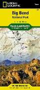
The map includes Big Bend National Park, Portions of Big Bend Ranch State Park, Black Gap Wildlife Management ARea, the Chisos Mountains, Sierra del Carmen, Sierra del Caballo Muerto, designated backcountry camping sites, park information, and more. Includes UTM tick marks for use with your GPS unit.

CHF 22.90

Sangre de Cristo Mountains Map [Great Sand Dunes National...

National Geographic Maps
Sangre de Cristo Mountains Map [Great Sand Dunes National Park and Preserve]
National Geographic's Trails Illustrated Maps are the most detailed and up-to-date topographic recreation maps available for US National Parks, National Forests and other popular outdoor recreation areas. A necessity for exploring the outdoors, each map is printed on waterproof, tear-resistant material. They also contain key safety and contact information, GPS and compass coordinates, Leave No Trace ethical guidelines and hundreds of points-of...

CHF 22.90

Telluride, Silverton, Ouray, Lake City Map

National Geographic Maps
Telluride, Silverton, Ouray, Lake City Map
National Geographic's Trails Illustrated Maps are the most detailed and up-to-date topographic recreation maps available for US National Parks, National Forests and other popular outdoor recreation areas. A necessity for exploring the outdoors, each map is printed on waterproof, tear-resistant material. They also contain key safety and contact information, GPS and compass coordinates, Leave No Trace ethical guidelines and hundreds of points-of...

CHF 22.90