National Geographic Britain and Ireland Wall Map - Classi...
National Geographic Maps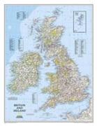
Our classic political map of Britain and Ireland shows country boundaries, thousands of place names, major highways and roads, airports, bodies of water, and more. Map is printed on premium quality paper stock, rolled, and packaged in a clear, hard plastic tube."Map Scale = 1:1, 687, 000Sheet Size = 23.5" x 30.25